Georeferenced orthomosaic and base mapping
LiDAR surveys and technical mapping 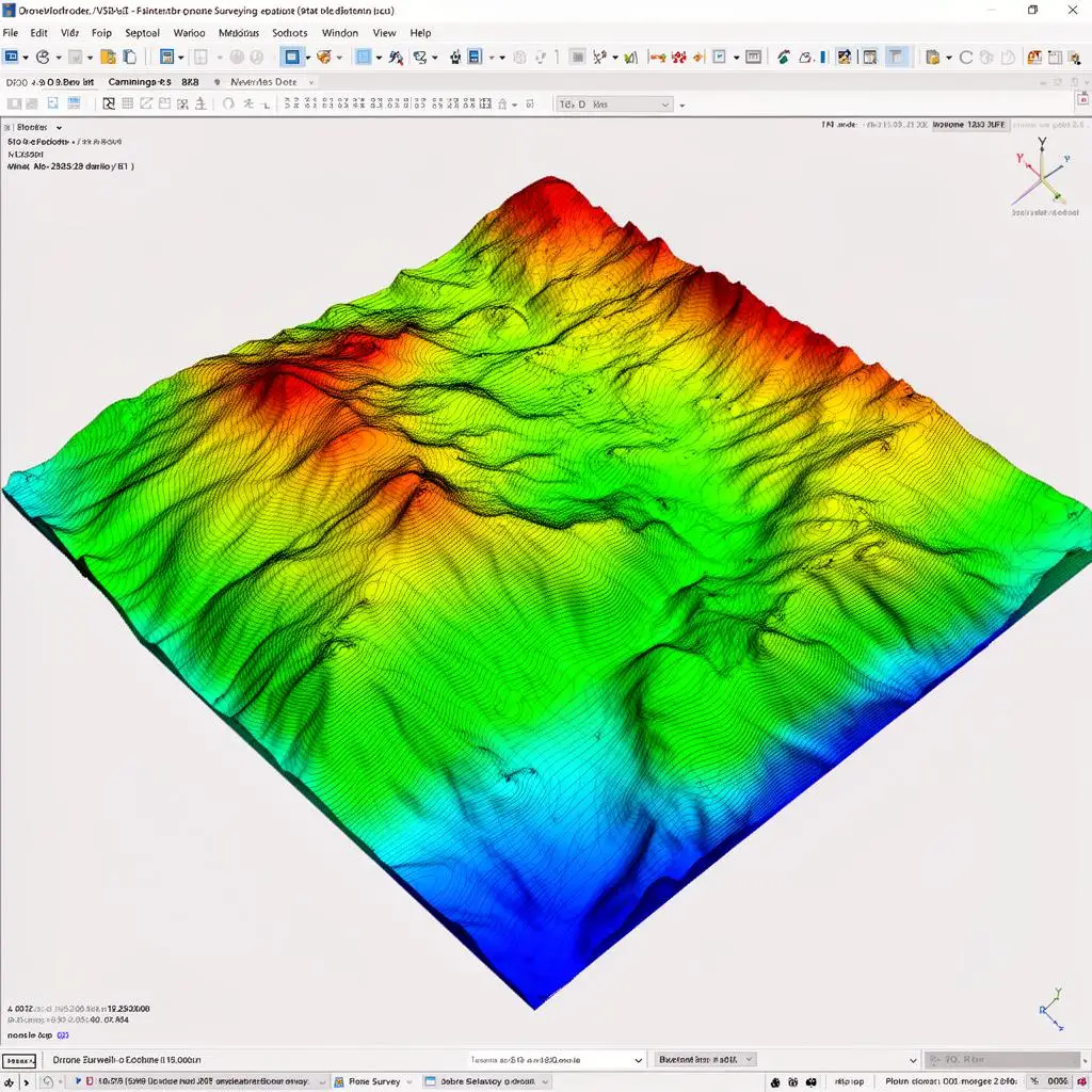
Drone LiDAR scanning for faster terrain data and mapping support
Service for worksites, properties and technical projects that need updated mapping, terrain context and clear digital deliverables.
Terrain model, point cloud and LiDAR support when the project calls for it
Support for engineering, worksites and land documentation
When drone LiDAR scanning is the right fit
It works well when a project needs up-to-date mapping, a terrain model or richer visual documentation to accelerate technical decisions.
Drone capture does not replace the technical side of the project, but it can shorten acquisition time and improve the quality of digital deliverables.
Typical LiDAR scanning deliverables
- Georeferenced orthomosaic for project review and base mapping.
- Digital terrain model, surface model or LiDAR capture depending on the project scope.
- Point cloud and 3D terrain model for technical or visual analysis.
- Contour lines and volumetric outputs when the project requires them.
- Support for land, slope, worksite and rural-property monitoring.
Best fit
Projects where it usually fits best
1
Pre-project land capture and worksite preparation.
2
Earthworks monitoring and terrain tracking.
3
Rural-property, road and parcel documentation.
4
Jobs that need both mapping and strong visual context.
Process
How a LiDAR scanning request is handled
1
Scope review
We review the goal, area, timing and type of output you actually need.
2
Flight planning and capture
We define the aerial workflow and capture the terrain with the right technical setup.
3
Processing and validation
The capture is converted into mapping products and digital models ready for use.
4
Final delivery
Files and project material are delivered in the format that best fits the end use.
LiDAR surveys and technical mapping
Drone LiDAR scanning for faster terrain data and mapping support
Service for worksites, properties and technical projects that need updated mapping, terrain context and clear digital deliverables.
- Georeferenced orthomosaic and base mapping
- Terrain model, point cloud and LiDAR support when the project calls for it
- Support for engineering, worksites and land documentation
Summary
When drone LiDAR scanning is the right fit
It works well when a project needs up-to-date mapping, a terrain model or richer visual documentation to accelerate technical decisions.
Drone capture does not replace the technical side of the project, but it can shorten acquisition time and improve the quality of digital deliverables.
Deliverables
Typical LiDAR scanning deliverables
- Georeferenced orthomosaic for project review and base mapping.
- Digital terrain model, surface model or LiDAR capture depending on the project scope.
- Point cloud and 3D terrain model for technical or visual analysis.
- Contour lines and volumetric outputs when the project requires them.
- Support for land, slope, worksite and rural-property monitoring.
Best fit
Projects where it usually fits best
Pre-project land capture and worksite preparation.
Earthworks monitoring and terrain tracking.
Rural-property, road and parcel documentation.
Jobs that need both mapping and strong visual context.
Process
How a LiDAR scanning request is handled
1
Scope review
We review the goal, area, timing and type of output you actually need.
2
Flight planning and capture
We define the aerial workflow and capture the terrain with the right technical setup.
3
Processing and validation
The capture is converted into mapping products and digital models ready for use.
4
Final delivery
Files and project material are delivered in the format that best fits the end use.
Tell us about the project
Contact Servidrone
The more context you send, the easier it is to assess the real scope and suggest the right service.
FAQ
Drone LiDAR scanning FAQ
What kind of outputs can I expect?
Typical deliverables include an orthomosaic, terrain model, 3D model, point cloud and derived outputs such as contour lines or volumetric calculations.
Is this suitable for worksites and earthworks?
Yes. It is one of the strongest use cases because it helps document initial conditions, monitor change and support terrain calculations.
Do I need to define the exact deliverable before asking for a quote?
Not necessarily. If you explain the project goal, we can help define the most useful output.